
Kentwood Is Looking At Big Impacts
This post originally appeared on ConcernedForWestchesterPlaya.com

Sleepy Kentwood, Big Impacts
Kentwood is a place I’ve called home for over 20 years. My husband and I were newlyweds and expecting our first baby when we bought our home.
The community is roughly bounded by Sepulveda, the Kentwood Bluffs, McConnell/Georgetown and Manchester. Kentwood is predominantly made up of a 3400 property homeowners association called Kentwood Home Guardians.
Kentwood is a very large physical portion of Westchester and consequently is subject to a lot of the city’s upzoning plans in the Community Plan Update (“CPU”) for Westchester Playa, second only to the wallop Osage is looking at.
Please sign and share our petition!
How Did We Get To This Point?
CPUs were announced for four westside communities in 2017. Inexplicably, Brentwood and Pacific Palisades were not included in this program, even though they are westside communities also due for updates to their CPUs. The project was supposed to last three years.
The first draft of the CPU dropped in mid-2020. The biggest impact for Kentwood was a dramatic upzoning of Manchester and rezoning our neighbors on 85th Place:
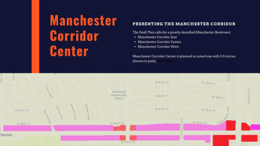
This is the full plan with some Kentwood implications, but primarily commercial implications along our corridors (mostly Manchester):
Anybody who saw the first draft nearly lost their minds with the aggressive upzoning. Kentwood Home Guardians held meetings about the plan for Westchester Playa. Our Neighborhood Council formed a special committee to study the plan.
A private group of leaders in our community worked very hard to write a coherent response to the draft. Who knew those would be the good ole days?
Then came COVID and everything stopped.
The Advisory Group
We knew the city was picking up the project again when it announced its handpicked Advisory Group in late 2022 for the combined CPU project known as “Planning The Westside.”
The Advisory Group was chosen by the City to be the sole voice to comment on the next round of drafts of our CPU. In fact, unbeknownst to us mere stakeholders, drafts were only provided to the Advisory Group via a special website.
Despite Westchester Playa being 25% of the combined plan areas, our area was given only five seats on the Advisory Group (out of 52), and all were for special interest groups. Not one person sat at that table for residential stakeholders in Westchester or Kentwood. One group member was the chair of the Planning & Land Use Committee for our Neighborhood Council, but nobody sat at that table tasked with speaking for residential stakeholders in our community.
Please sign and share our petition!
The Next Draft Plan Starts Dribbling Out
The next draft plan dribbled out only to the Advisory Group website and via three different maps, titled Residential Map, Commercial Map and Industrial Map.
These maps were not announced to the general public. They were posted only on the Advisory Group Website and the rest of us were left to discover them on our own.
And discover them we did. And we’re hopping mad at what we found.
Residential Map Implications On Kentwood
The Residential Map for the Community Plan Update shows Kentwood’s southeast section (WPDR 3) being radically upzoned from single-family to six on a lot (one unit per 1,000′ of lot). Read our full Residential Map analysis here.

Why Kentwood In The Southeast Corner?
We can’t figure out exactly why Kentwood is being targeted for radical upzoning (as in 6 units on a lot), but we’ve sleuthed out two possible reasons.
The first possible reason is a TOC designation at Sepulveda/Manchester, which I wrote more about in City Planning Has Lost Its Mind. Is LAX Watching?
The problem with TOCs based on bus service is that they are transitory. A developer can get big incentives to build density in a TOC and then overnight buses can fall out of favor.
And when did anybody paying market rate for a new apartment even take the bus?
I digress.
The second possible reason this particular cluster of upzoning might be because a metro rail stop is coming to Manchester/Sepulveda in about 30 years. Cue the eyeroll.
How Bad Could It Get?
No matter what the reason, the southeast corner of Kentwood is currently marked for upzoning that could result in as many as 2310 units. That is a 6x increase in units in a small area.
And that might not even be the worst case scenario.
The Correspondence Key for the Residential Map says 4 on a lot (“4L”) is our limit, but the planners have been vague about whether ADUs are allowed in addition to the 4 units, bringing the 5 unit threshold into play.
Let’s just say that my calculation of 2310 units in southeast Kentwood might be the best case scenario. The Housing Element is lurking in the background and we definitely need to start looking at it more closely.
What Other Consequences Might We Be Forgetting?
Builders developing on single family lots do not have to make infrastructure contributions and due to the proximity of the TOC, will not have to provide parking.
And please don’t forget that only a fraction of this density craziness will provide any affordable housing (as in like 10% which leaves us with the other 90% to deal with for no good reason).
We will be blighted with high-rise market rate boxes that forecasted declines in our Westchester population simply do not support.
Will all these units be built? No, but that is the worst part of the problem.
The city plans to rezone, not take your property in exchange for fair market value and develop a coherent, cohesive vision now.
Rezoning simply means that any random developer can buy the lot next door to you and build whatever crazy project the new zoning will allow, whether we need it or not, and without community input.
This is worse than eminent domain. We’ll all be tripping over each other to be the first to sell before our property is diminished in value by the 5-story monstrosity next door. Yuck!
The Residential Map is a big problem for Kentwood.
Please sign and share our petition!
Commercial Map Implications On Kentwood
Then came the Commercial Map. Notwithstanding its name, this map is really more residential than commercial. It contemplates first floor commercial with stories and stories of units over the commercial uses.
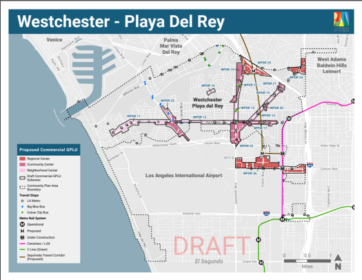
There are multiple implications for Kentwood on the Commercial Map. First, the map still shows rezoning for Manchester from the first draft plan, marked as WPDR 12 on this map.
The area, shown in light pink on the new map, will be zoned as a “Neighborhood Center.” Neighborhood Centers can be 3-5 stories and will range from 1 residential unit/1200′ of lot space to 1 residential unit/200′ of lot space.
If the lot next door to you in a Neighborhood Center district is 6,000′ (typical in Kentwood), that means five units to 30 units up close and personal to you on the lot next door.
Can you imagine 30 units next door???
And the same is true for the Little Von’s area, marked as WPDR 16 on the map, as well as WPDR 13 along Sepulveda in South Kentwood.
And that’s just the LIGHT pink implications.
Look at WPDR 18 & 19, the dark pink districts. Those are marked on the map as encroaching north Kentwood and gobbling up Arizona, if not also Alverstone (it’s very hard to read these maps).
Dark pink represents “Community Centers” and those can be up to 8 stories and allow five units to 15 units per 6000′ of lot space.
As you can see, Kentwood is getting slammed on the Commercial Map, too.
Industrial Map Implications On Kentwood
Well hallelujah! Nothing on the Industrial Map to report for Kentwood.
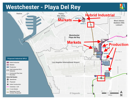
It is hard to read the map, but WPDR 27 & 31 are not in Kentwood. They are Arizona Circle on Centinela.
Nothing to see here, thank goodness.
Please sign and share our petition!
What Comes Next?
The planners say they’ll work on a combined map and issue it in October-ish. That map will be the plan that goes into the EIR process in January. The planners have indicated they might send two plans into EIR.
The EIR process is about studying the “impacts” of the proposed plan(s). Many of our questions to the planners have been deferred as relating to “impacts.”
The EIR process is also when the planners plan to “solicit” our input.
You don’t have to wait until then. The planners claim they are reading all email now. If you’d like to give them an earful, here is their contact info.
Is All Lost?
Is it time to sell and get out of Dodge? Hopefully not. I know many of us have been in Kentwood for decades and love our little Mayberry.
The planners sit in cubicles and draw these maps. They are not paying attention to the fact Kentwood is landlocked and they are not paying attention to the implications of LAX on our arteries. They definitely haven’t acknowledged that we have 2 million square feet of commercial space coming with the Northside Project.
The Alliance hopes to bring these facts to their attention. How can they really (with a straight face) say they want 15-story residential buildings on Sepulveda when that is a main arterial for LAX?
How can they add huge density to Manchester when that is our main east west corridor? And inland beach goers use it to access beaches. Playa del Rey will need Manchester for emergency purposes if there is a tsunami.
Where is common sense in this process?
Planners have waved off these questions, claiming they’ll be reviewed in the EIR process. The Alliance, with your help, wants them to acknowledge these limitations now, even before the EIR process, but we’ll see.
For sure we need more Kentwood neighbors paying attention to this process and willing to activate on request during the EIR process. We have got to show up as engaged and informed. There is a tremendous amount of political will both at city hall and in Sacramento behind the narrative that we need to “build our way out of our housing crisis.”
Follow our website for updates and please share it with your neighbors. We are following developments very closely and regularly meeting with our planners and other city representatives and posting what we learn to help shine a light on this process.
What Else Can You Do?
Please support the Alliance. The Alliance is comprised of residents from most of our neighborhoods and seeks to speak for our entire Westchester Playa community. We need a united voice and it’s not enough for Kentwood to rise up and say “no” to upzoning. There needs to be a broader plan for the entire plan area that the city will accept.
The Broader Housing Element
At the time this page was published, the content offered is strictly about the Community Plan Update. Be aware that the city is also working on its Housing Element with additional zoning implications for Westchester and Kentwood. We will update this page as more is learned.
Please sign and share our petition!
Tracy is active in a number of local community organizations including the Neighborhood Council PLUC, Neighborhood Council Ad Hoc CPU Committee, Kentwood Home Guardians and Emerson Ave Community Garden Club. The views expressed in this post are Tracy’s alone, and should not be construed in any way as an opinion of any other group. Are you planning a meeting with the planners? Have Tracy along to make sure you get the same information other community members get. Are you willing to host a group of your neighbors for a talk? Tracy and Lisa would be happy to join you.

About Tracy Thrower Conyers Tracy Thrower Conyers is a long-time resident of Westchester 90045. Tracy closely follows local politics, political players and social chatter relevant to Westchester. You’ll frequently find her at Neighborhood Council meetings, as well as on all the social platforms where 90045 peeps hang out. Tracy is a real estate broker and founding principal in Silicon Beach Properties. She is a recognized expert on Silicon Beach and its impact on residential and residential income real estate, and has been featured by respected media outlets including the LA Times, KPCC and KCET. Tracy is also a licensed attorney and accidental housing policy junkie.